Ultimate Guide to Carros de Foc Hiking
A complete Carros de Foc guide, covering the iconic circular trek through the Aiguestortes i Estany de Sant Maurici National Park in the Catalan Pyrenees.

Quick links
The Carros de Foc is the most popular high-mountain circuit in the Pyrenees. It’s a circular route connecting nine mountain refuges inside Aigüestortes i Estany de Sant Maurici National Park.
For hikers looking for a concentrated mountain experience - with big alpine landscapes, comfortable refuges, and a clear circular itinerary through one of Spain’s most impressive national parks—the Carros de Foc is hard to beat.
About Carros de Foc Hike
Start & Finish point: Espot (circular route)
📏 Distance: ~57 km
⏱️ Time to complete: 5–7 days
⛰️ Elevation: +11,700 m
⚖️ Difficulty: High, a major physical challenge even for experienced mountain hikers

The Carros de Foc circles through the heart of Aiguestortes National Park in the Catalan Pyrenees.
It’s a demanding trek that requires strong fitness, previous mountain experience, and stable weather, with steep climbs, rocky terrain, and several high passes along the way.
Carros de Foc vs Other Pyrenean Routes
If you're planning a mountain trek in the Pyrenees, several classic routes stand out as the most popular choices. These are the ones hikers most often compare when deciding how challenging, scenic, or remote they want their journey to be:
Carros de Foc – the legendary circular refuge-to-refuge route in Aiguestortes (which you already know from this guide).
GR11 – the long-distance traverse across the Spanish Pyrenees, offering weeks of walking from Atlantic to Mediterranean.
HRP (Haute Randonnée Pyrénéenne) – the high-route option, much wilder and more demanding, for hikers who want the most remote and technical experience.

The Pyrenees offer incredible diversity for mountain hiking, and these routes represent the core of almost every serious trekker's planning. Below, you'll find some quick comparisons to help you choose which one fits your style.
1. Carros de Foc
The Carros de Foc stays entirely within Aiguestortes National Park and follows a circular route linking nine mountain refuges. It stays at high altitude throughout, regularly crossing passes above 2,500 metres. This makes it ideal for hikers who want concentrated alpine scenery with comfortable refuge accommodation every night.

The full circuit is about 57 kilometres and takes 5 to 7 days to complete.
2. GR11
The GR11 runs the entire length of the Spanish Pyrenees from the Atlantic to the Mediterranean. It covers nearly 850 kilometres and takes 40-50 days to complete. The route passes through the Aiguestortes region where it briefly overlaps with the Carros de Foc.

The GR11 is far longer than the Carros de Foc and offers more varied terrain. Hikers who want a long-distance journey with changing landscapes often choose the GR11.
3. Pyrenean High Route
The HRP is the most demanding of all Pyrenean routes. It follows the ridgeline along the Franco-Spanish border and stays at high altitude for most of its length, crossing numerous passes above 2,500 metres. The route frequently requires scrambling and navigation skills.

The HRP is less clearly marked than the Carros de Foc or GR11, and route-finding experience is essential. It offers the most dramatic alpine scenery but requires strong fitness, technical confidence and the ability to navigate in challenging conditions. The HRP is best suited to experienced alpinists looking for a serious challenge.
Quick Comparison
Route | Duration | Elevation | Difficulty | Villages & Resupply | Best For |
Carros de Foc | 4–7 days | Very high (multiple passes >2,500 m) | Hard – steep, rocky, sustained days | None during the loop; refuges only | Hikers wanting a short, intense alpine circuit |
GR10 | 40–55 days | Moderate (rarely above 2,500 m) | Physically demanding but non-technical | Frequent access to villages and refuges | Hikers wanting infrastructure, culture & variety |
GR11 | 40–50 days | Moderate to high | Similar to GR10, slightly more remote | Less frequent than GR10 | Those preferring sunnier, drier southern conditions |
HRP | 40–50 days | High (often above 2,500 m) | Very hard, some scrambling required | Minimal, long gaps between resupply | Experienced trekkers seeking a true alpine challenge |
When to Hike the Carros de Foc
The main hiking season on the Carros de Foc runs from late June to late September, when high passes are free of snow and all refuges are fully staffed and open. Snow melts later at altitude, so some passes may still hold patches in early June. By early July, the entire circuit is usually clear and safely walkable.
Below is a clear breakdown of what each season offers so you can choose the best time for your Carros de Foc adventure:
Late June–July: Early season — snow finally melts on high passes; cooler mornings and excellent visibility
August: Peak season — warm, busy, and storm-prone in the afternoons
September: Ideal window — stable weather, mild temperatures, quieter trails
October–May: Winter conditions — snow, ice, and extremely dangerous for hiking without mountaineering skills
Spring (April–June)
Spring arrives slowly in the high Pyrenees. April and May bring heavy snow above 2,000 metres, with all high passes still completely covered. By mid to late June, the circuit becomes accessible, though some exposed sections may still hold ice.

Temperatures: Valley floors typically range between 10–18°C, while high passes remain cooler at 5–12°C.
Best for: Hikers who prefer cooler weather, dramatic early-season landscapes, and don't mind occasional snow patches.
Good to know:
High passes may hold snow into late June
Early June offers great conditions but requires flexibility and ice axe skills
Streams run high, making water plentiful but some crossings tricky
Summer (July–August)
Summer is the busiest and most reliable period on the Carros de Foc. Days are long, all refuges are fully staffed, and the entire circuit is accessible. Expect warm temperatures at lower elevations and pleasant conditions at altitude — along with frequent afternoon storms.

Temperatures: Valley areas sit around 18–28°C, while higher terrain ranges from 10–18°C.
Best for: Long days on the trail, high passes, spectacular lake scenery, and hikers wanting full refuge services.
Good to know:
Afternoon thunderstorms are common — early starts are essential
Refuge accommodation fills quickly in August, booking ahead is critical
Heat can be intense on south-facing slopes and exposed terrain
Autumn (September)
September is widely considered the best month to hike the Carros de Foc. Temperatures cool, visibility improves, and crowds thin as summer holidays end. All refuges remain open until late September, making logistics straightforward.

Temperatures: Lower sections range from 12–22°C, with higher areas at 6–14°C, creating crisp, clear hiking conditions.
Best for: Stable weather, lighter crowds, perfect visibility, and completing the full circuit.
Why go in September:
Stable, predictable weather
Cooler temperatures ideal for steep climbs
Fewer hikers and easier refuge bookings
Beautiful autumn colors around the lakes
Winter (October–May)
Winter brings heavy snow, ice, and extremely limited access. All refuges close for the season, and the circuit becomes a serious mountaineering expedition. Only experienced winter alpinists with avalanche training should attempt the Carros de Foc at this time of year.

Temperatures: Lower areas average 0–10°C, while high elevations often stay well below freezing.
Best for: Experienced winter mountaineers only — not recommended for trekking.
Good to know:
Snow and ice persist well into spring
All sections require crampons, ice axe, and avalanche awareness
Short daylight hours drastically reduce progress
No refuge accommodation available
What to Do in Bad Weather
Weather in the Pyrenees can change quickly, especially in July and August. A sunny morning can turn into thunderstorms within hours. If you hear thunder or see storms building, descend immediately to the nearest refuge — high passes and exposed ridges become extremely dangerous very fast.
All refuges offer common rooms where you can wait out poor weather, rest, or adjust your itinerary. The circular nature of the Carros de Foc also makes it easy to skip a stage or reverse direction if conditions deteriorate.
Carros de Foc Stage-by-Stage
Stage 1: Espot → Refugi d'Amitges
📏 Distance: 11 km
⏱️ Time: 5–6 hours
⛰️ Elevation: +1,200 m
⚖️ Difficulty: Moderate

This first stage begins at Estany de Sant Maurici and follows a steady climb through forest and open alpine terrain. You pass several lakes, including Estany de Ratera, before reaching Refugi d’Amitges. It’s a straightforward introduction with consistent ascent and reliable trail conditions.
Stage 2: Refugi d'Amitges → Refugi de Saboredo
📏 Distance: 8 km
⏱️ Time: 5–6 hours
⛰️ Elevation: +800 m / –800 m
⚖️ Difficulty: Hard

This stage crosses Collada de Contraix (2,758 m), one of the highest and steepest passes on the route. The climb involves loose rock and exposed sections, followed by a long descent into Vall de Saboredo. It’s a tough day with significant elevation change.
Stage 3: Refugi de Saboredo → Refugi de Colomers
📏 Distance: 7 km
⏱️ Time: 6–7 hours
⛰️ Elevation: +1,300 m / –600 m
⚖️ Difficulty: Very Hard

Often considered the most demanding day, this stage includes two high passes—Collada de Dellui and Collada de Colomers—plus technical sections and sustained climbing. The terrain is rocky and progress can be slow. Expect a challenging full-day effort.
Stage 4: Refugi de Colomers → Refugi de Restanca
📏 Distance: 10 km
⏱️ Time: 5–6 hours
⛰️ Elevation: +900 m / –800 m
⚖️ Difficulty: Moderate

This is a more manageable stage with mixed terrain and moderate ascents and descents. The route passes several small lakes before reaching Estany de Restanca and its refuge. It’s a balanced day compared to the harder previous stages.
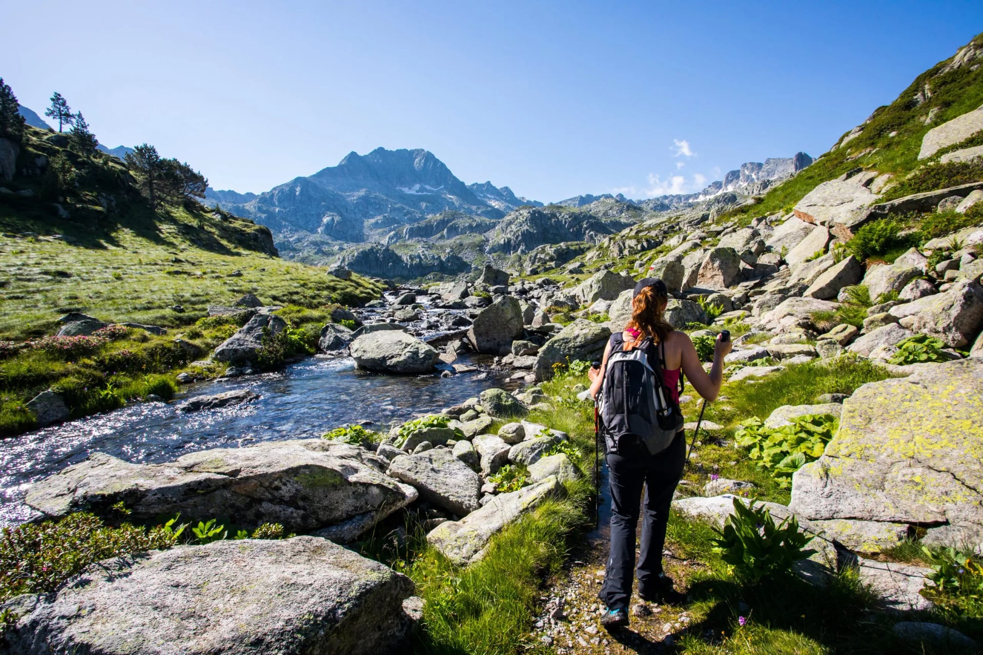
Stage 5: Refugi de Restanca → Refugi de Ventosa i Calvell
📏 Distance: 10 km
⏱️ Time: 5–6 hours
⛰️ Elevation: +950 m / –850 m
⚖️ Difficulty: Moderate
.JPG&w=1920&q=85)
The route climbs to Collada de Ventosa (2,585 m) and then descends to the Ventosa i Calvell refuge. The trail includes some rocky sections but is generally well-defined. This stage marks the end of the high-mountain part of the circuit.
Stage 6: Refugi de Ventosa i Calvell → Valley Return
📏 Distance: 8–10 km
⏱️ Time: 3–4 hours
⛰️ Elevation: Mostly descent
⚖️ Difficulty: Easy

The final day involves a simple descent back to the valley. Terrain is easier and less technical, making it a straightforward finish to the circuit.
How Much Time Do You Need on the Carros de Foc
A full Carros de Foc circuit is an intense but deeply rewarding mountain adventure. While it’s possible to complete the loop in 5 to 7 days, the optimal timeframe is 7 days. This pace gives hikers enough time to absorb the scenery, manage long ascents, and enjoy the high mountain passes without feeling rushed.
Seven days also means you’re better equipped to handle variable weather, take breaks at the refuges, and maintain steady energy throughout the route. The Carros de Foc is not a trail you want to race—its beauty lies in the remote valleys, granite cirques, and glacial lakes that deserve time.
Some hikers do complete the circuit in 5 days, but this requires long, demanding stages with little margin for weather or fatigue. For many, that feels more like an endurance challenge than an alpine trek. That’s why others opt to walk just a partial section instead.

Mountain Huts along the Trail
The Carros de Foc offers a unique hut-to-hut hiking experience. This makes planning straightforward since you'll be staying in mountain refuges each night. Throughout the circuit you will find:
mountain refuges,
fully staffed in summer,
half-board meals included,
dormitory accommodation and
comfortable common areas.
Mountain refuges provide everything you need for comfortable mountain nights. These are staffed in summer and offer half-board meals, bunk rooms and basic facilities. They are simple but very comfortable, and they eliminate the need to carry camping gear or large amounts of food. During July and August, it is essential to book in advance. More information about refuges is available on our Pyrenees Refuges page.
Staying in mountain refuges gives you a genuine alpine experience. Most are run by dedicated mountain guardians who know the terrain intimately. In addition, evenings often include hearty meals, local conversations, and shared experiences with other hikers completing the circuit.
It is one of the most enjoyable parts of the Carros de Foc experience and we can help by organizing your refuge accommodations and offering a range of Pyrenees tours that fit your schedule.
Is Camping Allowed on the Carros de Foc
Camping on the Carros de Foc is restricted since the entire route lies within Aiguestortes National Park. Wild camping is not permitted, and park rangers actively enforce this rule to protect the fragile alpine environment.

However, bivouacking near refuges is sometimes tolerated if you set up after sunset and leave at sunrise. This rule is intended for emergency situations or late arrivals. Always check with the refuge guardian before pitching a tent.
The Carros de Foc is designed as a refuge-to-refuge trek, and camping adds unnecessary weight while providing minimal benefit. The refuges are comfortable, serve excellent food, and are perfectly positioned along the route.
Getting to the Carros de Foc
You can walk the Carros de Foc clockwise or counterclockwise, but most hikers begin in Espot and walk counterclockwise. This direction tackles the easier stages first, giving you time to acclimatize before the hardest passes. Walking clockwise is perfectly viable, just steeper from day one.
How to Get to and from Espot
Most hikers begin the Carros de Foc in Espot, a small mountain village at the eastern entrance to Aiguestortes National Park. Espot is accessible by car or bus from La Seu d'Urgell or Lleida. This makes it one of the most convenient starting points in the Catalan Pyrenees.
From Barcelona or Lleida, drive to La Seu d'Urgell and then take the scenic C-13 road north to Espot (approximately 2.5 hours from Lleida). Regular buses run from Lleida to Espot during the summer months.

The Carros de Foc returns you to your starting point, which eliminates any complicated return transport. After completing the circuit, you finish back in Espot where you started, making logistics extremely simple.
Many hikers choose to walk only a section of the Carros de Foc rather than the entire circuit. For these shorter trips, Espot remains the primary access point. The western entrance at Boi is also accessible and allows you to join the circuit from that direction. Both villages have accommodation, shops, and seasonal bus connections.
Major International Airports
Spain has several international airports that provide convenient access to the Catalan Pyrenees and the Carros de Foc trailhead.
Barcelona-El Prat Airport (BCN) – The closest major airport to Aiguestortes. Ideal for starting the Carros de Foc from Espot. Approximately 3 hours by car.
Toulouse-Blagnac Airport (TLS) – Located in southern France, offering good connections to the western Pyrenees. About 3 hours from the Aiguestortes region.
Lleida-Alguaire Airport (ILD) – A smaller regional airport closer to the mountains, useful for direct access to the Catalan Pyrenees. Limited international connections.
Girona-Costa Brava Airport (GRO) – An alternative to Barcelona, slightly further but often cheaper. About 3.5 hours from Espot by car.

We often suggest that hikers spend a day or two in Barcelona or Lleida before or after the trek to explore the local culture and adjust to the time zone.
Ready to plan your trip? Explore our Carros de Foc itineraries and find the route that fits your timeline.
Essential Packing List for the Carros de Foc
Packing for the Carros de Foc requires mountain-specific gear. The route stays at high altitude throughout, with frequent exposure to wind, sun, and sudden weather changes. This list outlines the essentials for a safe and comfortable trek.
If you hike with us, we'll provide a customized Carros de Foc packing guide based on your route and travel dates.
Passport (valid for at least 3 months beyond your return date)
Hiking boots – broken in, ankle support essential, waterproof
Trekking poles – essential for steep descents and scree crossings
Backpack (40-50L sufficient for refuge-to-refuge hiking)
Hiking clothes: moisture-wicking base layers, hiking pants/shorts, fleece or insulated jacket
Waterproof jacket and pants – weather changes extremely fast at altitude
Hat and sun protection – sunglasses, high-SPF sunscreen, lip balm with SPF
Warm layers – temperatures drop quickly at altitude, even in summer
Lightweight clothing for evenings in refuges
Refuge shoes or sandals for comfort after hiking
Reusable water bottle or hydration system (2-3L capacity recommended)
Headlamp with extra batteries
First aid kit – including blister treatment, pain relievers, and any personal medications
Phone + charger + EU plug adapter (Type C or F for Spain)
Power bank to keep devices charged (refuges have limited outlets)
Maps and guidebook – printed or downloaded offline
Credit/debit cards and euros in cash – refuges prefer cash payment
Local SIM card – easy to get upon arrival in Spain for connectivity in villages
Practical Tips for Your Carros de Foc Trek
Currency and Payments
Spain uses the Euro (€) as its official currency.

ATMs are available in Espot and Boi but not along the trail itself. Most refuges accept cards, but carrying cash is essential as card machines can be unreliable at remote mountain refuges.
Tipping is customary but not obligatory, rounding up or adding 5–10% for excellent service is appreciated at refuges.
Emergency Numbers and Safety
Spain is generally a very safe country for hiking, but it's always good to be prepared.
The general emergency number is 112. It connects you to police, ambulance, mountain rescue, and fire services. In remote mountain areas, reception can be very limited, so always let someone at your refuge know your planned route and expected arrival time at your next refuge.
Useful Catalan and Spanish Phrases for the Trail
Here are 20 useful phrases that might come in handy during your trek:
Hola (OH-la) – Hello
Bon dia (bon DEE-a) – Good morning (Catalan)
Adeu / Adios (a-DAY-oo / ah-dee-OHS) – Goodbye
Gracies / Gracias (GRAH-see-es / GRAH-thee-as) – Thank you
Si us plau / Por favor (see oos plow / por fa-VOR) – Please
Si / No (see / noh) – Yes / No
Perdoni / Disculpe (per-DOH-nee / dis-KOOL-peh) – Excuse me
Parla angles? (PAR-la an-GLES) – Do you speak English? (Catalan)
No entenc (noh en-TENG) – I don't understand (Catalan)
Quant costa? (kwant KOS-ta) – How much does it cost? (Catalan)
On es…? (ohn es) – Where is…? (Catalan)
Aigua / Agua (AY-gwa / AH-gwa) – Water
El refugi (el reh-FOO-zhee) – The mountain hut
La farmacia (la far-MAH-see-a) – The pharmacy
El cami (el ka-MEE) – The trail / path
Estic cansat/cansada (es-TEEK kan-SAT/kan-SA-da) – I am tired
Una cervesa, si us plau (OO-na ser-VEH-sa see oos plow) – A beer, please
Esta bonissim (es-TAH bo-NEE-seem) – It's delicious (Catalan)
Bona excursio! (BOH-na eks-koor-see-OH) – Have a good hike! (Catalan)
Necessito ajuda (neh-seh-SEE-toh a-ZHOO-da) – I need help (Catalan)
Plan Your Carros de Foc Hiking Adventure
Planning a trek on the Carros de Foc means juggling refuge availability, weather windows, mountain fitness requirements, and balancing daily distances so the route stays enjoyable instead of exhausting. All of this can get overwhelming—especially in July and August, when refuges fill up fast.
If you'd prefer to skip the logistics and simply focus on experiencing the mountains, consider one of our supported hiking options:
We can also help you plan a custom itinerary that covers the very best sections of the Carros de Foc without any organisational stress.
Send us your dates, and we'll create a personalised Carros de Foc hiking plan tailored to your pace and experience level.


HASSLE-FREE
We handle itineraries, accommodations, and anything else you prefer not to deal with, so you can enjoy a carefree hike.

BOOK WITH CONFIDENCE
We are a financially protected company, fully bonded and insured, keeping your money safe and allowing you to travel with confidence.

TRIED & TESTED ADVENTURES
Only the best hut to hut hikes in Europe, cherry-picked by our local team with an in-depth knowledge of the region.

UNBEATABLE SUPPORT
Our 24/7 customer support is where we show our passion, bringing you a better experience by making your well-being our number one priority.